|
 |
Directions and maps
to some of our
favorite riding places.
ID Parks and Rec Trail Maps
Antoine Peak Conservation Area
Marie
Creek Trail
Red Ives
Liberty Lake Park
Squaw Valley
Pee Wee Creek
Bernard
Peak Trail h
Escure
Ranch
4th of July Pass
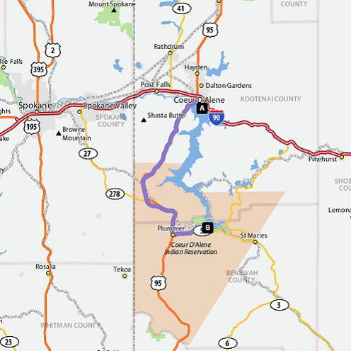
Heyburn State Park
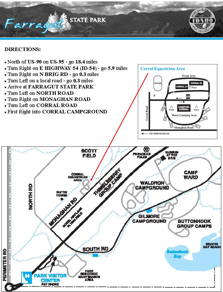
Farragut State Park
Chilco Mtn
Riverside State Park
Blue Creek Bayy
Fordyce Trail
|
|
|
| FORDYCE TRAIL HEAD, Asotin WA |
Directions to trailhead: After going down the Lewiston grade, drive through Lewiston City Center and cross bridge into Clarkston. On the bridge stay in left lane. After crossing bridge take the diagonal street to Clarkston City Center and Asotin. At next stop light turn left following same signs. It will take you Approximately 2 to 2 1/2 hrs from CDA to get to Clarkston. From Clarkston continue on same road, Hwy 129, going south through town and then along Snake River Rd,, 5 miles to Asotin. As you come into Asotin, turn before bridge, first road in Asotin, on (Beaumaster Drive) Asotin Creek Rd #110. When you come to a "Y" keep right and stay at creek level. Road will go back and forth from paved to gravel. After the third time it changes to paved and gravel, go right at the next "Y" intersection. In a few miles you will go past a couple barns on the right and a cattle guard. After the second barn. look for a sign along the left side of road (Fordyce Trail Head), a large grassy area with a parking lot. You are there. It is about 45 minutes from Asotin and the road is always in good condition. |
|
| ANTOINE PEAK CONSERVATION AREA |
Trent to Campbell Road in Spokane Valley.
Turn north onto Campbell Rd. Go 1.6 miles to Lincoln and then go west on Lincoln for 1 mile to the parking area located on the southside of the road. |
|
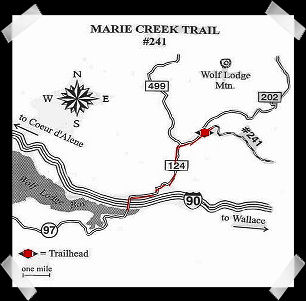
MARIE
CREEK TRAIL |
|
From
I-90 east of Coeur d'Alene take the Harrison exit
(# 22) and turn north. Turn
right at the stop sign on the frontage road.
Go
1.4 miles and turn left on Wolf Lodge Road. After
4.5 miles turn right on Marie Creek Road.
After
approximately 2 miles turn right on the one-lane entry to the
trailhead. There is no trailhead sign there (or if there was,
it was buried in weeds), but where the entrance splits away
there is a large sign stating that motor vehicles must stay
on designated roads.
Back to Top |
|
| RED
IVES -- Click HERE for map. |
DIRECTIONS:
Red Ives is on the upper part of the St Joe River above the
town of Avery. A sure fire
way to get there is take I-90 to the Hwy 3/Rose Lake
exit #34, go south to St Maries.
At about
22 miles there is a stop sign/light at the Hwy 3/Hwy 97 Harrison "Y".
From there go about 10.25 miles, at the 35 Miles speed sign
and Avery/Caulder sign, take a left onto St Joe
River Road (NF-50). It's about 90 miles from St Maries to Red
Ives all on paved roads.
Approximately
at the 73 mile marker there’s a bridge on the
right to Red Ives that crosses Gold Creek. Look for one of
our red and white PBCH arrow signs. The last 10 miles
is paved, but narrow with few turnouts, so take it slow and
carefully. Again, look for one our red and
white PBCH arrow signs at the Red Ives Historic
Ranger Station directing you across the bridge to the camping
area. |
|
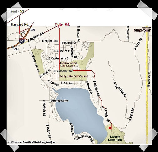
| LIBERTY LAKE PARK |
As
the map shows, there are several ways to get there, depending
on where
you’re coming from.
One example would be:
From E Appleway in Liberty Lake, WA, turn south on
Molter Rd. Go approximately 1 mile and turn left (east) on
E. Valleyway Ave. This road will take you between two
golf courses. It looks like you are going into the golf
course. Just follow the road to the Liberty Lake County
Park Horse Trail Head which is a large area with plenty of
parking for trailers on the right side of the road. You can't
miss it.
Good
horse trails.
Back
to Top |
|
|
| SQUAW
VALLEY |
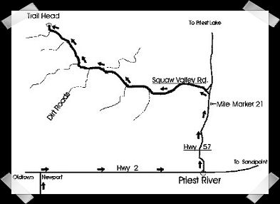
Note
from Connie: I have never ridden this area but have done some
trail work there. I hear that the entire loop
is approx.
20 miles long with little or no water along the trail. There
is a water trough hidden in the trees on the north
side of the trail head. There are also some steep trails. I would
recommend that you take shorter day rides in
this area. Plenty of room for trailers and camping.
|
Directions to Trail Head:
From CD’A, Rathdrum area, take Hwy 41 to
Newport. At light, turn right onto Hwy 2 to Priest
River.
Once in Priest River, turn left on Hwy 57 to Priest
Lake.
Just beyond
mile marker 21, turn left on Squaw Valley Road. (If you reach
the Information
Center, you went too far.)
You
are now on Road 312. It’s
a gravel road, then pavement, then gravel
again. Keep going straight.
From this point on, always stay to the
right until the road ends at the
trail head. From Hwy 57 it will
take about ½ hour to reach the
trailhead, which is a dead end.
Back
to Top
|
|
PEE
WEE CREEK |
Panaramic views of Priest River Valley.
Trail is
well groomed with some steep sections. There are several
small bridges to cross.
Some riding experience is required.
Stock
water at trail head. Approximately 3.5 or 5 hour ride. Plenty of parking for rigs.
Camping is free, no
hook-ups. Highline posts available. |
Directions: Take Hwy 57 north out of Priest River. (Same as Squaw
Valley map above) Go 3.5 miles to
Peninsula Rd.
Turn right, go across bridge, proceed 4.5 miles, turn left onto
gravel Forest Service Road #334
(Gleason-McAbee Falls Road), proceed 1 mile. Trail head is on the left just
past the old gravel pit.
Horses
should be shod.
Back
to Top |
|
BERNARD
PEAK TRAIL |
Option 1: Go Hwy. 54 toward Farragut Park. At the traffic circle turn right or south onto Good Hope Rd. Go about 1/4 mile to Hell Roaring Rd. Turn left and drive to the end cul-de-sac. Plenty of parking.
Option 2: From
junction of highways 95 and 54 in Athol, go east 4 miles on
54 toward Farragut State Park. At the traffic circle turn right/south
on Good Hope Rd. Go 0.6 miles and turn left on Twete Rd. Go
1.4 miles to where road makes right angle turn at Westwinds
Paso Ranch. Park on road or in clearing to left -- back in
or you will have to back out! There is a steel bar forest gate
at the beginning of the dirt road but you can ride through
the woods around it.
It
is an easy-grade 45 minute walk from the trailhead to the
lake overlook. Ride east on dirt road on the north side of
the Paso ranch's fence, when you get close to their buildings
the road turns away and begins to climb. About a mile in
there is another forest gate but easy to get around.
Shortly
after that another road splits off to the right up the hill
-- ignore it and stay left. A little ways further another
road splits off to the right, ignore it and stay straight/left.
Then a trail to the left but ignore that too, this goes down
to
Farragut I believe. Soon after that you will come to another "Y" where
both branches look equally used, stay left again.
Then you will see the forest sign saying "Lake View", Scout Trail".
Go straight
and the overlook is just a little further.
It is a beautiful view and there is a bench installed for hikers to rest on.
You
can go back to the Scout Trail and continue all the way up
to the peak, I
was told the total trail is about 8 miles.
There
are a few steep sections near the overlook, and early in
the season may
have a lot of downed trees the whole
way up. It is a good workout for the
horses. You will meet a few hikers and
a LOT of mountain bikers.
There
is one more viewpoint just off the trail at a switchback
about halfway up, but other than that there are no views,
even from the peak, the trees are too thick and tall.
|
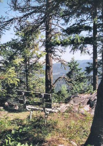
~ Bernard
Peak Overlook Bench~
The
trail comes out on a forest road near the peak, you just
follow the road up for a short distance as it curls around
and ends at the peak or there is a steep trail that shortcuts
up.
The
only water is a couple of tiny creeks between the trailhead
and the overlook.
On
the way back down from the peak, you will come to an intersection
with a sign that you may have missed on the way up, which says
steep trail this way, easier trail that way. The steep trail
is the Scout Trail, the easier trail (logging road) ends up
at that last "Y" you went
through on the way to the overlook.
Thanks to Karen Bratcher for the
photo and directions.
Back
to Top |
|
ESCURE
RANCH
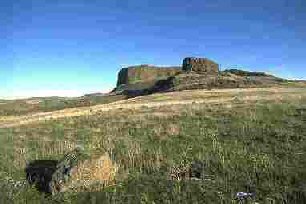
This
location is southwest of Sprague,
WA and has a beauty of its own. Very different than the beautiful wooded trails
we normally ride.
Today
the Escure Ranch, which is 20,000 acres, is owned by the Bureau
of Land Management (BLM) and offers spectacular scenery resulting
from the Great Missoula Flood as it carved its way through
the scab rock during the ice age to create deep hidden basalt
channels. I was in awe at the rock formations, cliffs and scenery
in this area. It is a great place to have a large group ride.
There
is plenty of room to spread out during the ride, park rigs,
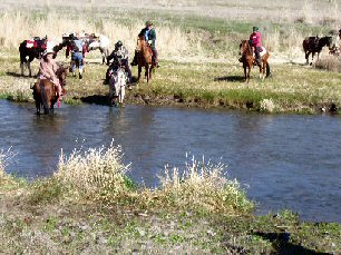
etc. Water trough at trail head. Creek crossings, and bridge,
depending on where you ride. There is also a large water fall
east of the ranch, but we didn't ride to it. There is cattle
on the property, so be sure to leave gates as you find them....
close any gates that you open. Practice the normal "Leave
No Trace" rules.
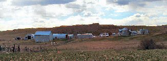
Trailhead
is located where this picture was taken from, right
before bridge going into the ranch. Ranch is currently vacant. |
Directions:
Travel west on I-90 past Spokane to exit for Sprague, WA. and Highway 23. Travel south on Highway 23 for 12.2 miles and turn right onto Davis Road. At 4 miles, stay to the right at the "Y". Continue south for 3 more miles and turn left onto Jordan Knott Road. Travel 2.1 miles and turn right onto the BLM access road, marked with a BLM Rock Creek Management Area Sign. Travel 2 miles to the recreation site at the road's end.
No fees to park or ride. Shared parking area for camping rigs. Several horse corrals and fire rings. Highline available.
Left:
John and Marcus Escure, Basque
immigrants from Spain, brought their
sheepherding skills to Eastern Washington.
While working as hired labor on others sheep
ranches, the Escures managed to build up their
own flock. In 1940 they acquired a 12,000 acre
ranch on which they started the Escure Sheep
Company.
Thanks
to Karen Bratcher for the photos and information.
Back
to Top |
 |
4th of JULY PASS
4th
of July Pass is located 13 miles East of Coeur d'Alene off
of I-90. At the Summit exit #28, go South and stay right on
Forest Road #614 for a quarter mile to the signed entrance
for the Park N' Ski Area. Lots of trailer parking available.
MAP
4th of July Pass
Park n Ski Area
Return
to Top |
|
HEYBURN STATE PARK
Directions: From Coeur d’Alene travel South on Hwy 95 approximately 34 miles to Plummer. At the flashing light, turn left (East) onto Hwy 5. Travel approximately 4.9 miles. There will be a gated road on the left side of the Hwy with a state sign on the right indicating that the horse trails are to the left.
|
|
 |
|
Chilco Mtn.
Directions to trail location:
Take Hwy 95 going N. to Bunco Rd. On Bunco go east or right off 95 for three miles. The Bunco then takes a left turn. Stay on this road for 14 miles as it turns into FS road #332. At intersection of #332 and #385 is where trail #14, starts. There isn't much parking, some 1/4 mile further on #332. This is a beautiful wide trail with great view points on two peaks. The entire trail one way is 17 miles. Submitted by Karen Kimball
|
|
Riverside State Park
If you are looking for a good place to ride during hunting season, try Riverside State Park in Spokane.
Directions are: take Maple St. exit, follow Second St till you get to W. Sunset Blvd. This road will cross Spokane River. Take a right on Government Way and follow for 3.3 miles and take a right on Aubrey L White Rd. Follow this road a short distance till you come to an open gate on the right that says equestrian center. Follow the dirt road up the hill to the end and you will be at the parking lot for day riding. The ride along the river going North is beautiful, especially in the fall. Submitted by Karen Kimball
|
|
Blue Creek Bay
Blue Creek Bay Recreation Area is a conservation area has some 736 acres to ride and hike next to the Coeur d'Alene Lake. The BLM acquired the land around the bay and now maintains the trails, the non motorized boat dock and the three picnic tables. BLM acquired the land with the help of the Wallace Forest family.
This land is located within the Wallace Forest Conservation Area east of Coeur d'Alene. At the boat launch area,it was a former landing used to dump logs into the lake where they would be floated down to one of several mills in the area.
The trail system has 3 loops including the longest blue loop followed by the orange and red loops. The trail is well marked and meanders up the hill and down back across Yellowstone Trail to the boat dock parking area. The other parking area along Yellowstone Trail has two hitching rails and room for four horse trailers and some eight passengar cars. There is room for 2 horse trailers to park alongside Yellowstone Road.
To get to the area from Coeur d'Alene, head east on I-90 to Wolf Lodge Bay exit 22. Then turn north and cross over I-90. Then turn left onto Yellowstone Trail Rd. for about two miles. The first main parking lot is on the right. The other parking area down by the boat dock is about 1/4 mile further and turn left onto Landing Rd.
Another way to get to the trail system is to take Mullan Trail exit off I-90. Then turn north and follow to Sunnyside Rd. Then turn left and stay to the left at fork in road. Road turns to gravel and then follow down the hill. At stop sign turn left onto Yellowstone Trail and then right onto Landing Road to the boat dock and parking. Or continue on Yellowstone Trail another 1/4 mile to upper main parking lot.
There is no water at either trailhead but there are portable toilets. Trails are non-motorized but there is some bicycle traffic on the trails.
The trail system meanders through ponderosa pine, Doug Fir, grand fir, western larch, western white pie, western red cedar, and western hemlock. As a result of past timber harvests, the area contains a mosaic of trees of varying types and sizes. Old logging roads and skids dot the hillside. Several meadows are also found on the property. Nice to ride in summer months and heat.
This is home to turkeys, whitetail deer, coyotes, bears, meadowlarks and woodpeckers.
A portion of the Mullan Road, the first constructed overland wagon route through the Northern Rockies, crosses through the uplands. Completed by hand in 1862, the trail connected points east of the Continental Divide to Fort Walla Walla, WA.
MAP
Blue Creek Bay Trail System
Information gleaned from Google of Blue Creek Recreation Area. Submitted by Joni Lueck
|
|